 Catalogue CIRAD
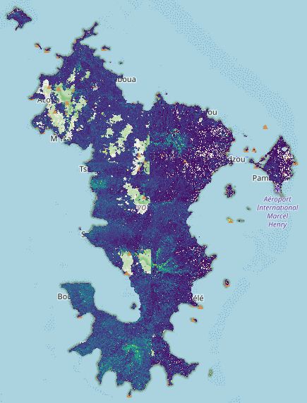
Mayotte - 2025 - DHM from Pleiades stereoscopic images
We are providing a Digital Height Model (DHM) derived from Pléiades images acquired by the Dinamis device in 2022. This DHM takes into account the damage caused by by Hurricane Chido in December 2024.
This data is freely available (CC-BY licence) provided that this reference is cited: "Dupuy, Stéphane, 2023, "Mayotte - 2022 - DHM from Pleiades stereoscopic images", https://doi.org/10.18167/GEODE/9273, CIRAD GeoDE, V1"
Simple
- Date (Creation)
- 2025-09-01
- Date (Publication)
- 2025-09-29
- Citation identifier
- urn:uuid/a79fc598-50d1-4c16-b3c4-db1de04800ff
Identifier
- Cited responsible party
-
Role Organisation Electronic mail address Custodian Author UMR TETIS
500 rue Jean François Breton34093 Montpellier Cedex 3France-
Dupuy Stéphane

-
Dupuy Stéphane
- Presentation form
- Digital map
- Purpose
-
The data published here are derived from Pléiades images acquired by Dinamis : https://dinamis.data-terra.org . This work is being carried out as part of the Biotamaya project (BIodiversity and Land Use in Mayotte and the West Indies).
A DSM (Digital Surface Model) was calculated from Pléiades images acquired in stereoscopic mode. The images were acquired in 2025 (between 12 May and 15 June 2022) and are available via the Dinamis catalogue. The DSM was calculated using the ForM@Ter cluster's online tool DSM-OPT (Digital Surface Models from OPTical stereoscopic very-high resolution imagery) : https://www.poleterresolide.fr
From the DSM, a DHM (Digital Height Model) was calculated by subtracting the DSM from the IGN ‘RGE Alti’ DTM with 1m spatial resolution.
In areas covered by clouds on the Pléiades images, the data was erroneous and was therefore deleted. The island of Mtsamboro was not covered by the Pléiades images (no DHM for this area).
This publication is based on the DSM webservice developed and performed by ForM@Ter, Solid Earth component of the Data Terra Research Infrasctructure
- Status
- Completed
- Point of contact
-
Role Organisation Electronic mail address Point of contact
- Spatial representation type
- Grid
- Topic category
-
- Imagery base maps earth cover
- Elevation
Extent
))
Temporal extent
- Time period
- 2025-05-12 2025-06-15
- Maintenance and update frequency
- Not planned
- Keywords
Resource constraints
- Language
- Français
- Character encoding
- UTF8
- Distribution format
-
-
GeoTIFF
-
- Distributor contact
-
Role Organisation Electronic mail address Distributor CIRAD
Centre de coopération internationale en recherche agronomique pour le développementSiège social42, rue Scheffer75116 ParisFrance
- OnLine resource
-
TETIS:Mayotte_DHM_2025_Stereo_Pleiades_v1
Mayotte MNH 2025 calculated from stereoscopic Pléiades images
- OnLine resource
-
Download in GeoTIFF format
- OnLine resource
-
Digital Object Identifier (DOI)
- Hierarchy level
- Dataset
Report
Result
- Date (Publication)
- 2008-12-03
- Explanation
-
Conformité aux règles d'implémentation INSPIRE pour les métadonnées
- Pass
- true
- Statement
-
Data produced from images obtained from the DINAMIS platform, funded by CNES, CNRS, IGN, IRD, INRAE, CIRAD.
- Reference system identifier
- EPSG:32738
- Reference system type
- Projected
- Maintenance and update frequency
- As needed
Metadata
- Metadata identifier
- urn:uuid/a79fc598-50d1-4c16-b3c4-db1de04800ff
- Language
- Français
- Character encoding
- UTF8
- Language
- English
- Character encoding
- UTF8
- Contact
-
Role Organisation Electronic mail address Point of contact
Type of resource
- Resource type
- Dataset
- Metadata linkage
-
https://geode.cirad.fr/geonetwork/srv/api/records/a79fc598-50d1-4c16-b3c4-db1de04800ff?language=all
- Date info (Creation)
- 2025-10-22T08:21:47.352081Z
- Date info (Creation)
- 2024-09-04T15:09:54.445096Z
- Date info (Revision)
- 2026-07-28T10:07:27.597345Z
Metadata standard
- Title
-
ISO 19115-3.2018
)))